To view this page in Spanish, scroll down to the Spanish content section. To view this page in a language other than English or Spanish, click on the drop-down menu in the upper right corner.
Para ver esta página en español, desplácese hasta la sección de contenido en español. Para ver esta página en un idioma distinto del inglés o el español, haga clic en el menú desplegable de la esquina superior derecha.
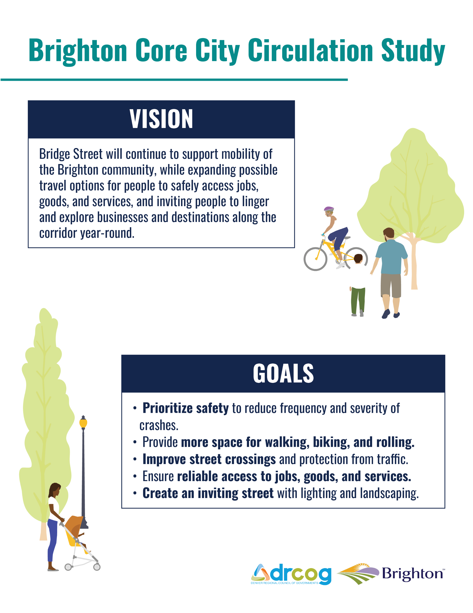
Project overview
The Brighton Core City Circulation Plan seeks to improve transportation options and safety along Bridge Street and access to Brighton’s historic downtown. The study area includes Bridge Street between the South Platte River to the west and 22nd Avenue to the east, plus about a half mile north and south of Bridge Street. DRCOG is leading this study in partnership with City of Brighton. This will be a 12-month study evaluating improvements that can be made for all modes of travel along the corridor.
Share your feedback
We want to make sure this plan reflects the diverse needs and ideas of people who live, work and travel along the corridor. Your perspective will be crucial in helping us create a representative plan that balances the needs of various community members, and we’d love for you to help guide our process!
As we kick off the first phase of the project, help us identify safety issues, mobility barriers, and opportunities for improvements in the study area. We will use your feedback to help us understand community needs and concerns and identify priorities and goals for the future of the study area.
To participate, you may:
Please share this feedback opportunity with others in the community! Both activities will close at the end of the day on Friday, April 25.
Survey: Tell us about traveling along Bridge Street today
Mapping Activity
To participate, you may complete the survey above and drop pins on the map to add comments about specific locations.
- Crossings Uncomfortable crossing the street here
- Sidewalks Sidewalks could be improved here
- Biking Bike lane or path could be improved here
- Transit Bus stop could be improved here
- Safety I have a safety concern here
- Key destination I commonly travel to this location
- Other Other idea or concern
Resumen de Projecto
El Plan de Circulación del Núcleo de la Ciudad de Brighton busca mejorar las opciones de transporte y la seguridad a lo largo de Bridge Street, así como el acceso al centro histórico de Brighton. El área de estudio abarca Bridge Street, entre el río South Platte al oeste y la 22nd Avenue al este, además de aproximadamente 800 metros al norte y al sur de Bridge Street. El Consejo Regional de Gobiernos de Denver (DRCOG) lidera este estudio en colaboración con la ciudad de Brighton. Este estudio, de 12 meses de duración, evaluará proyectos que se pueden implementar para mejorar el transporte en todos los modos (tránsito, caminando, manejando, andando en bicicleta, etc) a lo largo del corredor.
Comparta sus comentarios
Queremos asegurarnos de que este plan refleje las diversas necesidades e ideas de las personas que viven, trabajan y transitan por el corredor. Su perspectiva será crucial para ayudarnos a crear un plan representativo que equilibre las necesidades de los diversos miembros de la comunidad, ¡y nos encantaría contar con su ayuda para guiar nuestro proceso!
Estámos iniciando la primera fase del proyecto. Ayúdenos a identificar problemas de seguridad, barreras de movilidad y oportunidades de mejorar el transporte en el área de estudio. Utilizaremos sus comentarios para comprender las necesidades e inquietudes de la comunidad e identificar prioridades y objetivos para el futuro del área de estudio.
Para participar, puede:
- Completar la encuesta.
- Colocar marcas en el mapa para agregar comentarios sobre ubicaciones específicas.
¡Comparta esta oportunidad de compartir sus comentarios con otros miembros de la comunidad! Ambas actividades finalizarán al final del día viernes 25 de abril.
Encuesta: Cuéntenos sobre su experiencia de hoy viajando en Bridge Street.
Actividad de Mapeo
Para participar, puede completar la encuesta anterior y colocar marcas en el mapa para agregar comentarios sobre ubicaciones específicas.
Para obtener ayuda con el uso de este mapa, por favor consulte las instrucciones.
- Cruces Incomodidad al cruzar la calle aquí
- Aceras Se podrían mejorar las aceras aquí
- Ciclismo Se podría mejorar el carril para bicicletas
- Transporte público Se podría mejorar la parada de autobús aquí
- Seguridad Tengo una preocupación de seguridad aquí
- Destino clave Suelo viajar a este lugar
- Otro Otra idea o inquietud